Essess completes Street View with IR heat maps
One of the outcomes was to conceive the equivalent of a Google vehicle fleet, equipped with a custom designed thermal imaging rig to perform infrared scans at street level.
The full roof-top mounted sensor package includes up to four longwave infrared (LWIR), four near infrared (NIR) cameras, two lidar units, a military grade GPS, and inertial motion unit, odometry, humidity, temperature, wind, and a variety of ancillary sensors. As the vehicle drives through the city landscape, it capture a 3D thermal video of the surrounding environment.

Essess’ car-mounted sensor rig.
Altogether, about 6TB of data is collected per vehicle per night (preferably over the winter period when properties are heated up).
As part of an energy efficiency program, the company started selling its services to government and military clients, offering them to analyse the energy waste across there building stock so they would better identify thermal leaks and optimise their energy efficiency investments.
Now, the company wants to go mainstream and reach consumers through its Thermal Analysis Program (TAP), a turnkey marketing program proposed to utility providers. The idea is that once a nation-wide coverage would be achieved, utility providers could systematically target home and building owners whose thermal envelop exceeds national averages, helping them identify the best fixes for consistent energy savings.
Some utility providers are already offering that sort of audit, usually through a manual acquisition using portable equipment, or even using drones to establish aerial heatmaps.
But Essess’ CEO Tom Scaramellino argues these audits are somehow cost prohibitive and lack the machine’s intelligence that is precisely built-in Essess’ solution.
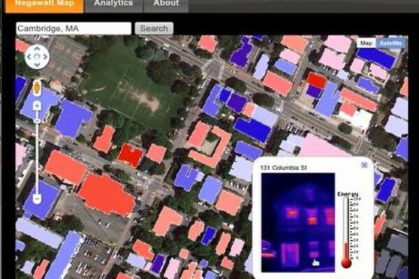
Just as an example, Scaramellino boasts that in a single evening, the company was able to scan over 17,000 buildings in Cambridge, MA, something that he estimates would have taken five years using traditional auditing methods.

Cambridge MA’s heat map as compiled by Essess over a night.
"Humans are very bad at doing this thermal envelop assessment job. They don’t have the understanding of how the sun’s orientation during the day and the building’s materials heat absorption properties impact the heat radiation later throughout the night. With a properly trained algorithm, a machine is much better at this task”. The company is also considering hyperspectral imaging as one way to further improve construction material identification, for a better correlation of the IR data with the material’s thermal properties. What’s more, the data captured for each home can be correlated to averages from similar constructions.
Now, since you only measure temperature differences and relative IR intensities, how do you make sure all the captured data is relevant, say if that night a particular building is not heated up? We asked Scaramellino.
“Right, we only measure the delta between indoor and ambient temperature, but since we work hand-in-hand with utility providers, we also correlate this info to meter data, so we know how much energy is being consumed”. This also allows electric and gas utilities to gain greater intelligence around their customer base. They can come up to their customers and suggest better insulation of specific building areas or rate their thermal envelop compared to their neighbourhood’s average.
In the long term, assuming a nation-wide heat map coverage could be achieved, would Essess envisage web-accessible services and applications such as a coloured thermal overlay over Google’s Street View? And in that case wouldn’t it make sense to partner with Google and share the same fleet of vehicles?
“For now, our business model is to sell our services to utility providers, which themselves offer the thermal street view for free to their customers, on an individual home basis because of privacy issues”, says Scaramellino. “Google on the other side relies on advertising revenue, so they can afford to give Street View away to enable more advertising services. We wouldn’t be able to give our data away, but sure, we think it would be a great idea to partner with Google to drastically increase our geographical coverage”.

For now, Essess keeps a close eye on new building energy efficiency standards and certification processes, lobbying to make its thermal imaging and data analytics solution a must have.
Visit Essess at www.essess.com
Related articles:
Add-on turns iPhone into thermal imaging camera
 If you enjoyed this article, you will like the following ones: don't miss them by subscribing to :